Wildland firefighters hit their STRIDE
You’re a hotshot working to contain a wildfire. The conflagration jumps the fire line, forcing your crew to flee using pre-determined escape routes. At the start of the day, the crew boss estimated how long it should take to get to the safety zone. With the flames at your back, you check your watch and hope they were right.
Firefighters mostly rely on life-long experience and ground-level information to choose evacuation routes, with little support from digital mapping or aerial data. The tools that do exist tend to consider only a landscape’s steepness when estimating the time it takes to traverse across terrain. However, running up a steep road may be quicker than navigating a flat boulder field or bushwacking through chest-high shrubs. Firefighters, disaster responders, rural health care workers and professionals in myriad other fields need a tool that incorporates all aspects of a landscape’s structure to estimate travel times.

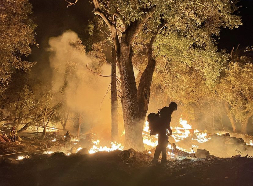
Photo Credit: Andrew Potter
Wildland firefighter works on a hotshot crew to contain a fire in California
In a new study, researchers from the University of Utah introduced Simulating Travel Rates in Diverse Environments (STRIDE), the first model that incorporates ground roughness and vegetation density, in addition to slope steepness, to predict walking travel times with unprecedented accuracy.
“One of the fundamental questions in firefighter safety is mobility. If I’m in the
middle of the woods and need to get out of here, what is the best way to go and how
long will it take me?” said Mickey Campbell, research assistant professor in the School
of Environment, Society and Sustainability (ESS) at the U and lead author of the study.
The authors analyzed airborne Light Detection and Ranging (LiDAR) data and conducted
field trials to develop a remarkably simple, accurate equation that identifies the
most efficient routes between any two locations in wide-ranging settings, from paved,
urban environments to off-trail, forested landscapes. They found that STRIDE consistently
chose routes resembling paths that person would logically seek out—a preference for
roads and trails and paths of least resistance. STRIDE also produced much more accurate
travel times than the standard slope-only models that severely underestimated travel
time.
“If the fire reaches a firefighter before they reach safety, the results can be deadly, as has happened in tragedies such as the 2013 Yarnell Hill fire,” said Campbell. “STRIDE has the potential to not only improve firefighter evacuation but also better our understanding of pedestrian mobility across disciplines from defense to archaeology, disaster response and outdoor recreation planning.”
The study was published on Sept. 13, 2024, in the journal Scientific Reports.
Airborne estimates of on-the-ground travel
STRIDE is the first comprehensive model to use airborne LiDAR data to map two underappreciated factors that inhibit off-road travel—vegetation density and ground surface roughness—as well as steepness. LiDAR is commonly used to map the structure of a landscape from the air, Campbell explained. A LiDAR-equipped plane has sensors that shoot millions of laser pulses in all directions, which bounce back and paint a detailed map of structures on the ground. The laser pulses bounce off leaf litter, gravel, boulders, shrubs and tree canopies to build three-dimensional maps of terrain and vegetation with centimeter-level precision.
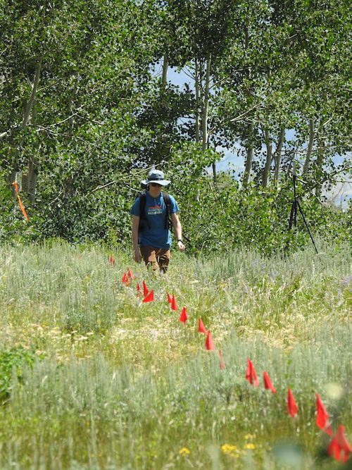
The authors compared STRIDE performance against travel rates gleaned from three field experiments, in which volunteers walked along 100-meter-transects through areas with existing LiDAR data.
Volunteers were timed walking 100-meter transects chosen to represent off-path landscape conditions, including nearly impassibly steep slopes and extremely dense vegetation.

Photo Credit: Utah Remote Sensing Applications (URSA) Lab
Volunteers were timed walking 100-meter transects chosen to represent off-path landscape conditions, including nearly impassibly steep slopes and extremely dense vegetation.
“Getting travel times from a variety of volunteers allowed us to account for a range of human performance so we can make the most accurate predictions of travel rates in a diversity of environments,” said coauthor Philip Dennison, professor and director of ESS.
The first field trials were in September of 2016. At the time, LiDAR datasets were relatively rare in the western U.S. Over the last decade, the U.S. Geological Society has developed LiDAR maps covering most of the country.
“When we first started looking into wildland firefighter-mobility a decade ago, there were lots of people studying how fire spreads across the landscape, but very few people were working on the problem of how firefighters move across the landscape,” said Campbell, then a doctoral student in Dennison’s lab at ESS. “Only by combining these two pieces of information can we truly understand how to improve firefighter safety.”
That study, that published in 2017, was the first attempt to map escape routes for wildland firefighters using LiDAR. The second trial took place in August of 2023 in the central Wasatch Mountains of Utah to ure a wider set of undeveloped, off-path landscape conditions than did the first experiment, including nearly impassibly steep slopes and extremely dense vegetation. The final experiment was in January of 2024 in Salt Lake City to test the STRIDE model in an urban environment. In total, about 50 volunteers walked more than 40, 100-meter transects of highly varied terrain.
Putting it together
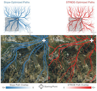
The study compared STRIDE against a slope-only model to generate the most efficient routes, or the least-cost paths, in the mountains surrounding Alta Ski Resort in the Wasatch Mountains, Utah. Geographers and archaeologists have been using least-cost path modeling to simulate human movement for decades; however, to date most have relied almost exclusively on slope as the sole landscape impediment. The authors imagined a scenario in which emergency responders are planning to rescue an injured hiker. From a central point, they chose 1,000 random locations for the hiker and asked both models to find the least-cost path.
STRIDE chose established roads around the ski areas, followed trails and in some cases major ski slopes, to avoid patches of forest or dense vegetation. STRIDE reused established paths as long as possible before branching off, reinforcing the idea that STRIDE identified the routes most intuitive for somebody on the ground.
Simulation of a scenario in which emergency responders are planning to rescue an injured hiker. From a central point, the authors chose 1,000 random destinations and mapped hiking routes using two different models: one that only accounted for slope steepness, and one based on STRIDE. STRIDE (right, red) reused established paths as long as possible before branching off, identifying the routes most intuitive for somebody on the ground. The slope-only model (left, blue) generated few overlapping pathways with little regard for roads or trails.
“The really cool thing is that we didn’t supply the algorithm with any knowledge of existing transportation networks. It just knew to take the roads because they’re smoother, not vegetated and tend to be less steep,” said Campbell.
In contrast, the slope-only model had few overlapping pathways, with little regard for roads or trails. It sent rescuers through dense vegetation, dangerous scree fields and forested areas.
The authors believe that STRIDE will have an immediate impact in the real world—they’ve made the STRIDE model publicly available so that anyone with LiDAR data and gumption can make their work or recreation more efficient, with a higher safety margin.
“If you don’t consider the vegetation cover and ground-surface material, you’re going to significantly underestimate your total travel time. The U.S. Forest Service has been really supportive of this travel rate research because they recognize the inherent value of understanding firefighter mobility,” said Campbell. “That’s what I love about this work. It’s not just an academic exercise, but it’s something that has real, tangible implications for firefighters and for professionals in so many other fields.”

Photo Credit: Campbell et al. Sci Rep (2024)
Simulation of a scenario in which emergency responders are planning to rescue an injured hiker. From a central point, the authors chose 1,000 random destinations and mapped hiking routes using two different models: one that only accounted for slope steepness, and one based on STRIDE. STRIDE (right, red) reused established paths as long as possible before branching off, identifying the routes most intuitive for somebody on the ground. The slope-only model (left, blue) generated few overlapping pathways with little regard for roads or trails.
The authors recently used a slope-based travel rate model to update the U.S. Forest Service Ground Evacuation Time (GET) layer,which allows wildland firefighters to estimate travel time to the nearest medical facility from any location in the contiguous U.S. Campbell hopes to use STRIDE to improve GET, allowing for more accurate estimates of evacuation times.
**********
The study, ‘A singular, broadly applicable model for estimating on- and off-path walking travel rates using airborne lidar data,” published in Scientific Reports on Sept. 13, 2024.
Sierra Cutler, graduate student at the U’s ESS, was a coauthor on the study.
About the Blog
Discussion channel for insightful chat about our events, news, and activities.
Categories
Featured Posts
Tag Cloud
- Alumni (1)
- Snow (2)
- Student Research (1)
- Dust (2)
- award (7)
- faculty research (9)
- remote sensing (1)
- Oquirrh (1)
- School of Environment Society and Sustainability (29)
- student research (3)
- park (1)
- planning (1)
- alumni (1)
- research (8)
- undergraduate (4)
- university (1)
- science (1)
- sustainability (5)
- environment (1)
- School of Environment (2)
- Society & Sustainability (2)
- student (2)
- scholarship (2)
- air (1)
- wildfire (3)
- air quality (1)
- climate change (2)
- urban tree (1)
- paleoecology (1)
- ethnobotany (1)
- cel (1)
- UAP (1)
- field research (1)
- open house (1)
- climate grief (1)
- field trip (1)
- organic farming (1)
- political ecology (1)
- taft nicholson center (1)
- writing retreat (1)
- Southeast Asia (1)
- Climate change (2)
- Environmental Justice (2)
- Great Salt Lake (1)
- Faculty research (3)
- Job posting (1)
- Data science (1)
- Climate Change (1)
- Rivers and Streams (1)
- Geology (1)
- Faculty Research (1)
- Green spaces (1)
- Invasive species (1)
- Forest ecology (1)
- Utah wildlife (1)
- water security (1)
- renewable energy (1)
- economic development (1)
